On LBI
Monday, August 3because you're ON the island, not in it!
Today · Monday, August 3
← LBI TownsMap · 18 miles · north to south

Map of LBI

Long Beach Island is a narrow barrier island on the New Jersey shore, about 18 miles long and in places only a few blocks wide — you can see Barnegat Bay and the Atlantic from the same street. It sits in Ocean County, and there is exactly one road on: the Route 72 Causeway, which lands you in Ship Bottom, roughly in the middle.

Map of Long Beach Island Towns

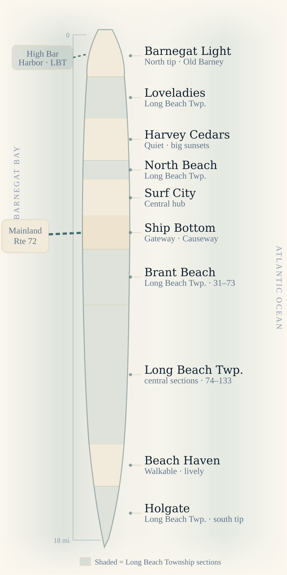
North is at the top. Tap any town to open its guide. The shaded bands are all Long Beach Township — it isn't one continuous town but five separate pieces woven between the boroughs, which is why Loveladies appears north of Harvey Cedars and High Bar Harbor hangs off the bay side at the top.

Map of Long Beach Island (LBI) towns, north to southATLANTIC OCEANBARNEGAT BAYMainlandRte 72High BarHarbor · LBT018 miBarnegat LightNorth tip · Old BarneyLoveladiesLong Beach Twp.Harvey CedarsQuiet · big sunsetsNorth BeachLong Beach Twp.Surf CityCentral hubShip BottomGateway · CausewayBrant BeachLong Beach Twp. · 31–73Long Beach Twp.central sections · 74–133Beach HavenWalkable · livelyHolgateLong Beach Twp. · south tipShaded = Long Beach Township sections

Tap or hover a town to see what it's like and what a beach badge costs. Tap again to open the full guide. The shaded bands are all one municipality — Long Beach Township, in five separate pieces.

How the Island Is Laid Out

LBI runs roughly north–south, so almost everything is described by how far up or down the island it sits. One road — Long Beach Boulevard — runs nearly its whole length, changing name to Bay Avenue through Beach Haven, and nearly every address on the island is a turn off it. Three landmarks are all you need to orient yourself:

  • North tip — Barnegat Lighthouse. “Old Barney” stands at the very top of the island in Barnegat Light, overlooking Barnegat Inlet.
  • Middle — the Route 72 Causeway. The only road on or off, landing in Ship Bottom. Everything is measured as north or south of this point.
  • South tip — the Forsythe refuge. Below Beach Haven, Holgate narrows to a peninsula ending in the Edwin B. Forsythe National Wildlife Refuge, closed April 1 – August 31 for piping plover nesting.

The ocean is always east, the bay always west. If the sun is rising over the water you're on the ocean side; sunsets belong to the bay.

Six Towns, Nine Stretches

A map of LBI labelled by municipality is misleading, because Long Beach Township is five separate chunks rather than one. Driving the Boulevard end to end you actually pass through nine distinct stretches:

#StretchMunicipality
1Barnegat Light + High Bar HarborBarnegat Light Borough
2LoveladiesLong Beach Township
3Harvey CedarsHarvey Cedars Borough
4North BeachLong Beach Township
5Surf CitySurf City Borough
6Ship BottomShip Bottom Borough
7Brant Beach → North Beach Haven (11 named villages)Long Beach Township
8Beach HavenBeach Haven Borough
9Holgate + Beach Haven InletLong Beach Township

Want the actual street where each line falls? See the boundary guide →

Getting to Long Beach Island

There is one way on and one way off by car: Route 72 east from Manahawkin, across the Causeway, arriving in Ship Bottom. From there you turn left for the north end — Surf City, Harvey Cedars, Loveladies, Barnegat Light — or right for the south — Brant Beach, the Township sections, Beach Haven and Holgate.

Because everything funnels through that single bridge, summer Saturday mornings inbound and afternoons outbound are the island's pinch point. Causeway traffic, parking and the LBI Shuttle →

LBI Map FAQ

Where is Long Beach Island on a map of New Jersey?

Long Beach Island sits off the southern New Jersey coast in Ocean County, roughly halfway between Atlantic City and Toms River. It is a barrier island separated from the mainland by Barnegat Bay, reached only by the Route 72 Causeway from Manahawkin, which lands at Ship Bottom.

How long is Long Beach Island?

About 18 miles from Barnegat Light at the north tip to the Forsythe refuge below Holgate at the south. It is very narrow — in places only a few blocks wide, with the ocean and Barnegat Bay visible from the same street.

What are the towns on LBI in order from north to south?

Barnegat Light, Loveladies, Harvey Cedars, North Beach, Surf City, Ship Bottom, then the long Long Beach Township run through Brant Beach to North Beach Haven, then Beach Haven, and finally Holgate at the south tip. Loveladies, North Beach and Holgate are all sections of Long Beach Township rather than separate towns.

How do you get onto Long Beach Island?

By the Route 72 Causeway from Manahawkin — the only road onto the island. It brings you in at Ship Bottom, near the middle, where you turn north or south along Long Beach Boulevard.

Is Long Beach Township one town on the map?

No, and this is the most common map mistake. Long Beach Township is non-contiguous: five separate pieces wrapped around the five boroughs. Loveladies sits north of Harvey Cedars, North Beach sits between Harvey Cedars and Surf City, the largest run stretches from Brant Beach to North Beach Haven, Holgate is the south tip, and High Bar Harbor is a bayside enclave at the north end.